


Snow has started in southern Nebraska. It will gradually expand to the to the northeast this morning. By noon, most of the area should be observing snow.
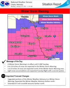
A winter storm warning is in effect for most of the area. A winter weather advisory is in effect in counties near the Nebraska, South Dakota border. Snowfall amounts in the winter storm area will range from 6 to 16 inches.
A widespread area of 9 to 12 inches are forecast for much of the area around Interstate 80. The highest amounts of 16 inches are forecast at and near areas by Nebraska City.
Northeasterly winds will blow at 15 to 25 mph during the event, with gusts as high as 30 to 35 mph at times. This will create areas of blowing snow during the day Monday.
Snowfall rates should range 1-2 inches per hour in areas of the heaviest snowfall. heavy, wet snow combined with strong winds could lead to power outages.
Travel will be difficult, if not impossible for the evening commute. After 12 PM, snow will accumulate quickly and roads will rapidly become snow covered.
Tuesday through Sunday: Snow from this system will linger into Tuesday morning and should come to an end by 6 AM. Additional snow is possible Tuesday night as another system moves into the area. Amounts from this 2nd system should be 1 inch or less.


